Komodo water visibility by month follows a clear seasonal arc: it bottoms out at roughly 10–15 m in January and February during the northwest monsoon, climbs through March and April as the seas settle, peaks at 20–30 m in May, holds broadly good through the dry season, and compresses again as the wet season returns. These figures are typical reported ranges drawn from a single resort climatology for central Komodo — not measurements we have taken ourselves — and they are presented here as orientation, last verified June 2026. They tell you what to expect on a standard day trip from Labuan Bajo. They do not tell the whole story for a snorkeler, because visibility at the surface and visibility at 20 m underwater are two different experiences. This page explains both.
The Monthly Table
The data below traces to a resort climatology source covering central Komodo — the main day-trip corridor from Labuan Bajo that includes Karang Makassar, Taka Makassar, Siaba Besar, Kanawa, and Pink Beach. Southern park sites, which receive stronger Indian Ocean upwelling, run cooler and may see different visibility patterns; they are primarily liveaboard territory anyway. Water temperature figures are from the same single source. Both columns carry the same uncertainty caveat: these are typical reported ranges, last verified June 2026 — not independent measurements and not a forecast.
| Month | Visibility (central Komodo, typical reported range) | Water Temperature | General Sea State |
|---|---|---|---|
| January | 10–15 m | 28–29°C | Rough; cancellations possible |
| February | 10–15 m | 28–29°C | Rough; harbor closures possible |
| March | 15–20 m | 28–29°C | Improving; transitional |
| April | 20–25 m | 28–29°C | Calm; dry season establishing |
| May | 20–30 m (reported peak) | 28–29°C | Calm; excellent conditions |
| June | 20–25 m | 27°C | Calm; trade winds settled |
| July | 15–25 m | 25–26°C | Calm surface; stronger subsurface currents |
| August | 15–25 m | 25–26°C | Calm surface; strongest currents of the year |
| September | 15–25 m | 25°C | Calm; currents beginning to ease |
| October | 20–25 m | 26°C | Good; season transition beginning |
| November | Not separately reported in source; est. 15–20 m | Est. 26–27°C | Variable; first monsoon rains |
| December | Est. 10–15 m | Est. 28°C | Rough; cancellations increasing |
November and December figures are estimated from seasonal patterns — the resort climatology cited does not specify these months. All figures last verified June 2026. Confirm current conditions with your operator before travel; park-wide visibility can shift significantly after heavy rain or a strong current event.
What the Numbers Actually Mean from the Surface
Here is the part that most snorkeling guides skip. Visibility figures in Komodo are almost always reported by divers, for divers. A diver at 15 m cares about seeing to 25 m or beyond because their entire environment is measured in horizontal distance underwater. A snorkeler at the surface is looking straight down. The experience at 10 m versus 25 m visibility is less dramatic than you might expect — and in some cases the snorkeler actually benefits from lower clarity in ways a diver does not.
At 10–15 m visibility (January–February, and estimated December)
The water looks green-blue rather than the cobalt you see in April or May. Looking straight down from the surface you can see perhaps 8–12 m of water column clearly. At Siaba Besar, where turtles rest and feed in 2–6 m of water, this is irrelevant — you will see the turtle at arm’s length regardless. At Karang Makassar (Manta Point), where mantas sometimes feed at or just below the surface, 10–15 m visibility is actually tolerable: the manta is in the top 3–5 m of the water column, and you are watching it from 0 m. The visibility loss hurts you most at Kanawa and the reef edges of Pink Beach, where the coral garden extends to 5–8 m and you want to read the formations below you clearly. In January–February, those gardens look murkier. You still see the reef. You just see less of it at once.
The bigger problem in January–February is not visibility — it is the sea state. Rough conditions mean surface chop, which exhausts snorkelers who are fighting to keep their mask clear and their breathing steady. And cancellations are real. Labuan Bajo’s harbor authority (KSOP) does close the port during unsafe swell conditions, sometimes with very little advance notice. If mantas are worth the trade-off to you and you have buffer days in your schedule, January–February can work. If your trip has a fixed return flight and one day to spare, the risk profile is unfavorable.
At 15–20 m visibility (March, and the Jul–Sep range floor)
This is a genuinely comfortable range for surface snorkeling. At 15 m clarity you can see the bottom clearly at Siaba Besar (mostly 2–6 m), read the coral structure at Kanawa to its full depth, and watch mantas moving through the water column at Karang Makassar. March carries this visibility while water is still warm — 28–29°C — which is arguably a sweet spot for comfortable multi-entry days without needing a wetsuit. The seas are improving from the wet season, crowds are low, and park fees are the same as peak season.
In July–September, the same 15 m floor appears alongside much colder water (25–26°C) and the park’s strongest subsurface currents. Visibility in the bottom half of that range — 15 m on a cloudy-current day in August — combined with fast drift at Karang Makassar is a more demanding environment than the same number in March. The surface is calm, which is why the peak season crowds are here, but conditions below the surface are a different matter. Something to factor into your assessment before entering the water with a weak swimmer or a young child.
At 20–25 m visibility (April, June, October)
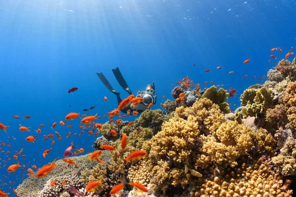
This is the sweet spot for snorkeling. At 20 m clarity, looking straight down from the surface in 5 m of water, the bottom is sharp. Coral textures are readable. A manta ray passing through the feeding zone at 3–4 m depth is visible in full silhouette. The colour rendering improves noticeably — corals that look washed-out at 10 m start showing their oranges and purples at this depth. From a practical standpoint, 20 m visibility means a snorkeler at the surface can see everything happening in the top 10 m of the water column without straining. That covers the vast majority of what Komodo’s snorkel sites offer.
April and June are my personal preference windows, for whatever that is worth. April combines this visibility range with 28–29°C water, dry-season reliability, and low-to-moderate crowds. June is nearly as good on visibility, slightly cooler at 27°C, and still pre-peak on the crowd calendar. October recovers to 20–25 m after the September floor and brings cooler crowds again — and manta aggregation is building again toward its November–February peak.
At 20–30 m visibility (May peak)
This is where the difference becomes tangible even from the surface. At 25–30 m clarity in calm conditions, the water in central Komodo looks genuinely blue rather than blue-green. The reef at Kanawa seems to float in open water. At Karang Makassar the sandy plateau below is bright and legible even in 12–15 m depth. For photography — and for the pure experience of being suspended over a reef in clear water — May is the strongest month on this single metric.
A few caveats. First, 20–30 m is a range, not a guarantee; the 30 m end requires calm conditions, minimal plankton, no recent rain runoff, and the right time of day (morning). Second, May is when the park is quietest before the July–August rush, but it is not deserted — this is also the month dive operators begin their peak-season scheduling. Third, manta likelihood in May is moderate at best: the November–February aggregation has wound down, and sightings are possible but not at their peak frequency. If you come to Komodo specifically for mantas in May, the visibility will be beautiful; the manta encounter rate may not match the expectation.
Why Visibility Drops in the Wet Season
The 10–15 m floor in January–February is not an anomaly — it has a direct cause. The northwest monsoon drives nutrient-rich water across the Flores Sea, which triggers phytoplankton blooms. Phytoplankton scatter and absorb light. The same plankton bloom that reduces horizontal visibility to 10–12 m is exactly what draws manta rays to Karang Makassar in the highest densities of the year. The reef is also experiencing its most productive biological moment — fish spawning aggregations, feeding behavior, increased invertebrate activity — while the visibility is at its low point for the camera-carrying snorkeler. This is not a coincidence. It is the mechanism.
March begins the transition. Plankton blooms thin as monsoon activity decreases and the southeast trade winds begin establishing. Visibility climbs to 15–20 m. By April the Flores Sea is clearing consistently, and by May the water reaches the peak clarity of the annual cycle. The process reverses in November as the northwest monsoon builds again.
River runoff plays a smaller role. Komodo National Park sits in one of Indonesia’s drier zones — annual rainfall is far lower than in Bali or much of Java — so freshwater runoff contributes less to visibility reduction than in more tropical coastlines. The plankton cycle is the primary driver.
Visibility Variations Across the Park — Not All Sites Are the Same
The monthly table above describes central Komodo: the main day-trip corridor from Labuan Bajo. Within that zone, site-level variation exists.
Karang Makassar (Manta Point)
Being an open-water plateau with strong tidal flow, Manta Point gets fresh, well-circulated water. Visibility here often runs toward the upper end of the monthly range. The tradeoff is current — stronger flow brings cleaner water, but it also makes the snorkel a drift rather than a leisurely swim. On days when operators describe the current as too strong and skip the entry, visibility is likely excellent. You just cannot benefit from it safely. The site sits at 5–15 m depth; snorkelers are floating over that range, watching whatever moves into the top 0–5 m.
Siaba Besar (Turtle City)
This is a sheltered, shallow site with mild currents — consistently one of the most beginner-accessible spots in the park. Its protected position means water is somewhat less flushed than Karang Makassar, which can soften visibility slightly on low-flow days. Even so, at 2–6 m depth and mild current, the practical snorkeling experience here is excellent across the entire dry season. The turtles are in the shallows regardless of what the monthly visibility column says — at 10 m depth and 15 m horizontal visibility, you are still going to see them clearly.
Kanawa
Protected bay, beach entry, 1–8 m depth on the reef edge. Kanawa benefits from its sheltered position — less current means cleaner-looking water in calm conditions, though also less flushing. During dry-season months with 20–25 m park-wide visibility, Kanawa is one of the prettiest snorkel experiences available on a standard day trip: shallow enough to free-dive easily, diverse enough to occupy 45 minutes without repeating yourself. In the wet season when park-wide visibility drops to 10–15 m, Kanawa is among the last sites to feel the full impact because of its sheltered geometry.
Pink Beach
Visibility at Pink Beach tracks the park-wide pattern closely — the bay is semi-exposed and the reef extends to about 5 m before reaching sandy flats. What affects Pink Beach more than most sites is anchoring pressure. Decades of boat anchoring have degraded coral cover in parts of the bay; where the substrate is rubbled, sediment suspension reduces local clarity regardless of the monthly forecast. This is the kind of thing the monthly table cannot capture. Your experience at Pink Beach in May with 25 m visibility and fresh current will be better than a flat description suggests; in August with 15 m visibility and disturbed sediment from a dozen anchored boats, it can disappoint. Time your entry to early morning before the mid-day boat concentration.
Planning Around Visibility: A Practical Checklist
Before you book, the following questions will help you translate the monthly table into an actual trip decision:
- What is your primary goal?
- If mantas, accept lower visibility and rougher seas in Nov–Feb. If clear water and calm conditions, April–June or October is your target. If both, October is a reasonable compromise as the manta aggregation builds and dry-season conditions still partially hold.
- How flexible is your schedule?
- If you have one fixed day in Labuan Bajo, the dry season (April–November) minimizes cancellation risk significantly. December–February: budget two buffer days minimum.
- What is your snorkeling experience level?
- For beginners and families: May, June, and April are the most favorable combination of visibility, sea state, and water warmth. Siaba Besar and Kanawa work well in nearly any dry-season month. Karang Makassar should be assessed with your guide on the day regardless of month.
- Do you need warm water for comfortable long sessions?
- Pack a 2–3 mm shorty for July–September. The surface is calm, but 25–26°C over multiple water entries on a full day will chill most people after the second or third session.
- Is this a photography trip?
- May maximizes both visibility and warmth. Come on weekdays when possible — July–August crowds are real, and a dozen snorkelers in the frame at Manta Point is a common outcome on peak-season group boats.
Ready to match your dates to the right tour format? Use our planning form or reach us via WhatsApp — we can steer you to an operator whose itinerary suits the month you are traveling and the conditions you care about most. No one can pay to change what we publish here; if you proceed with our partner operator Komodo Luxury (a sister brand within Juara Holding Group, disclosed), they may pay us a referral fee at no extra cost to you.
Cross-Reference: Visibility and the Best-Time Decision
Visibility is one variable in a multi-factor decision. The full month-by-month breakdown — incorporating sea state, manta likelihood, crowd levels, and cancellation risk alongside visibility — is covered in the best time to snorkel Komodo guide, which also arbitrates the contradictions between different sources on manta season timing. If you are planning a June trip specifically, the June conditions breakdown in that piece covers current state and crowd patterns in more detail than is possible here.
One more honest note on source quality: the resort climatology data behind this table is useful and internally consistent, but it is one resort’s recorded observations — not an instrument network, not a government monitoring dataset, not an average across multiple independent sources. It describes central Komodo and will not match conditions at every site on every day. Treat it as a well-informed baseline, verify with your operator in the week before you travel, and adjust expectations for any site that is known to deviate from the park-wide pattern (the southern sites in particular).
Frequently Asked Questions
What is the best month for water visibility snorkeling in Komodo?
May consistently reports the highest visibility in the typical resort climatology data for central Komodo — 20 to 30 m is the recorded range. April and June are close, at 20–25 m, with calmer seas and warm water. The upper end of the May range (25–30 m) requires settled conditions, minimal recent rain, and a morning departure; it is not guaranteed every day of the month. Last verified June 2026.
Does poor visibility in January and February mean snorkeling is not worth it?
Not necessarily. At 10–15 m visibility, you still see turtles clearly at Siaba Besar (they are in 2–6 m of water), and manta rays feeding at or near the surface at Karang Makassar are visible from above regardless of horizontal range. The visibility reduction matters most at deeper reef edges and in photography where you want a clean background. The bigger practical issue in January–February is sea state: rough conditions and the risk of cancellation affect the trip more significantly than the clarity of the water does.
Why does visibility in July and August vary so much — 15 to 25 m is a wide range?
The dry season brings calm surface conditions to central Komodo in July–August, but also the strongest subsurface currents of the year as tidal flows accelerate through the narrow straits. On high-current days water is flushed and clear — toward the 25 m end of the range. On low-current or overcast days with reduced light penetration, the same water reads closer to 15 m. Wind-driven surface chop can also suspend fine particles on exposed sites. This variability is why the July–September column spans 15–25 m rather than giving a single figure: site conditions on any given day depend on tide timing, recent weather, and your specific position in the park.
Does visibility differ between the north and south of Komodo National Park?
Yes, significantly. The monthly figures in the table apply to central Komodo — the main day-trip corridor around Karang Makassar, Taka Makassar, Siaba Besar, Kanawa, and Pink Beach. Sites in the southern park, including the dive-specialist sites in the Manta Alley zone, receive stronger Indian Ocean upwelling. Water temperature at southern sites is reported as low as 22–25°C even during peak dry season, and the different water-mass dynamics mean visibility patterns there may not follow the central park model. Most standard day trips from Labuan Bajo do not reach southern sites; if you are booking a liveaboard itinerary that includes them, ask your operator about current conditions specifically for those locations.
What visibility should I expect if I travel in June right now?
Based on the typical reported ranges for June — 20–25 m in central Komodo, water around 27°C — current conditions should offer good to excellent snorkeling visibility. June sits solidly in the dry season: seas are calm, the trade winds are established, and crowds are building toward July–August peak but not yet at maximum. For sites like Siaba Besar, Kanawa, and Karang Makassar, these are among the better conditions of the year for a surface snorkeler. That said, a single recent storm or a heavy current event can temporarily reduce visibility well below the monthly average. Confirm actual conditions with your Labuan Bajo operator a few days before your trip — they will have real-time reports from recent departures. All figures last verified June 2026.
Questions about timing, tour options, or which sites suit your group? Plan your trip here — our planning form or WhatsApp line can match your actual travel window to the right format and operator.